Groundwater is one of the most important and most misunderstood natural resources shaping our future. Beneath our cities, industrial zones, transportation corridors, and fast-growing communities exist vast, unseen aquifers. They are the “hidden rivers” that keep projects resilient, sustainable, and compliant.
And yet, too often, groundwater imaging is treated as a box to check. A low-bid survey. Minimal interpretation. Something to “get out of the way” so drilling or design work can move forward.
But engineers, hydrologists, city planners, and land developers already know how risky that mindset is.
Engineering teams today face enormous pressure to deliver predictable schedules, manage budgets, and reduce liabilities. When the subsurface behaves unexpectedly, that is, when an unconfined aquifer appears where it shouldn’t, or a clay lens pinches out faster than anticipated, the project delays stack up. Drilling plans shift. Environmental compliance tightens. And sustainability goals become harder to meet.
This is why groundwater mapping is the foundation of responsible planning and conscious urbanization, and not just some step in the process.
Why knowing how to map groundwater matters
Across the U.S., water stress is increasing, particularly in fast-growing cities. Many states are already dealing with declining aquifer levels, restrictions on groundwater use, or soils impacted by past water mismanagement. Against this backdrop, city planners, engineers, and developers are now expected to:
- Plan infrastructure that remains viable for 40–60+ years
- Predict groundwater availability, quality, flow direction, recharge, and seasonal fluctuation
- Identify and avoid contamination pathways during construction
- Design foundations and utilities around a dynamic water table
- Integrate groundwater sustainability into environmental and permitting frameworks
- Prevent drainage issues, flooding, or long-term land subsidence due to overpumping
For example, if you’re planning to build a new municipal facility, it’s no longer enough to know where the groundwater sits today. You need to understand how it will behave over decades of climate variability, regional pumping, and changes in recharge. This requires real subsurface understanding and not guesswork based on sparse well data.
A question we hear constantly is: “How accurate can geophysics really be when predicting groundwater?”
The short answer: When done properly (with the proper method, correct data acquisition settings, disciplined field data acquisition, and geological modeling), geophysics is one of the most reliable, scalable tools available for groundwater exploration, planning, and management.
It cannot replace conventional drilling, but it can dramatically reduce unnecessary drilling, identify the highest-probability targets, map aquifer attributes (i.e., geometry, depth, thickness), and reveal risks long before they become construction problems.
How we map groundwater
Different groundwater problems require different approaches. Here’s how modern geophysical methods, when applied correctly and interpreted through a geological lens, reveal precisely what engineers need to know.
1. Electrical Resistivity Imaging (ERI) — The gold standard for exploring groundwater-bearing formations.
ERI works by injecting a controlled electrical current into the subsurface and measuring how the earth resists its flow. Saturated materials, especially those with electrically conductive groundwater, have distinct electrical resistivity signatures.
How deep can ERI go? In most U.S. terrains, ERI can reliably image from a few feet to 400+ ft, depending on array size, electrode spacing, and ground conditions.
ERI excels at distinguishing:
- Saturated vs. unsaturated zones
- Fresh water vs. saline intrusion
- Permeable sand/gravel aquifers vs. clay-rich aquitards
- Fractured rock zones with higher groundwater flow potential
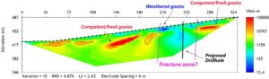
Suppose a land developer wants to position a new distribution center. In that case, ERI can measure electrical resistivity and, from there, infer the depth of the water table, identify perched aquifers that may cause localized flooding, and reveal clay barriers that affect drainage. This prevents foundation redesigns later.
2. Time-Domain Electromagnetics (TDEM) — Deep, fast, wide-area groundwater imaging
TDEM uses electromagnetic induction to detect changes in subsurface electrical conductivity. Because it samples large volumes of earth quickly, it is ideal for projects requiring deep or broad coverage, such as:
- Transmission corridors
- Solar/renewable energy fields
- Large utility expansions
- Municipal groundwater management zones
Many engineers ask whether EM can differentiate between lithology and groundwater. The answer: yes, when paired with geological modeling.
EM conductivity is strongly influenced by:
- Saturation level
- Groundwater salinity
- Clay content
- Porosity and fracturing of the geologic units
With proper inversion and modeling, TDEM provides some of the clearest aquifer-scale images available.
For instance, before planning a new solar farm, a developer might need to evaluate whether a deep, brackish aquifer underlies the site, which could affect corrosion, trenching, or long-term infrastructure resilience. TDEM provides that clarity quickly.
3. Ground Penetrating Radar (GPR) — High-resolution shallow groundwater mapping
GPR uses high-frequency radar pulses to detect changes in near-surface materials. It’s extremely useful for shallow subsurface characterization, such as:
- Subgrade and pavement assessments
- Utility corridor planning
- Environmental monitoring
- Dewatering design
- Construction QA/QC
However, GPR does not perform well in conductive materials (i.e., clay-rich soils or saturated media), which is why method selection matters. A low-cost GPR-only survey on a clay-heavy site often produces almost no meaningful information about groundwater.
If, say, a city plans to rehabilitate a roadway system, GPR can identify shallow groundwater pockets that weaken subgrade performance and lead to premature pavement failure.
4. Seismic, GPR, Magnetics, SP, and Borehole Logging — The critical complements
Groundwater behavior is controlled by geology, not just the presence of water itself. This is where many low-cost geophysical surveys fail: they produce data and results without the geological component.
To interpret groundwater correctly, CGS relies on a multi-method, geology-first approach:
- Seismic (Refraction, MASW)
Defines depth to bedrock, stiffness contrasts, and velocity layers that influence water storage and permeability. - Ground-Penetrating Radar (GPR)
It helps identify the top of shallow aquifers and groundwater pollution pockets. - Magnetics
Identifies buried channels, paleo-valleys, and structural controls that influence groundwater flow patterns. - Spontaneous Potential (SP)
Assists in locating or mapping fluid-bearing geological structures (fractures, faults) that might capture or release water. - Borehole geophysical logging
Calibrates electrical resistivity and EM models against high-resolution formation data, ensuring high accuracy.
For example, before designing an expansion of a wastewater treatment plant, seismic and resistivity data can be combined to identify whether the underlying geology promotes natural drainage or traps water, thereby increasing uplift forces on structures.
This integrated approach is what transforms raw data into engineering insight.
The high cost of doing improper geophysics
We understand the pressure to keep budgets tight and projects on schedule. We understand the scheduling demands, procurement constraints, and the temptation to take the lowest bid just to say the geophysics was done.
But here’s the reality we see every year in the field.
A cheaper, single-method survey can easily miss a perched or thinner aquifer. When drilling encounters unexpected groundwater, the result is almost always delay, added cost, and unnecessary risk. Low-resolution geophysical surveys often misinterpret a clay lens as a saturated zone, sending foundation design in the wrong direction and forcing expensive corrections later. Outdated or shallow-only scans frequently misrepresent the depth to competent material, leading to structural assumptions that do not hold up once construction starts.
And surveys that provide data without geological interpretation leave teams with attractive visuals but no real answers or the ability to make confident engineering decisions.
Groundwater for Sustainable Futures
Water is no longer a secondary environmental consideration. It is becoming one of the defining engineering constraints for U.S. development in the next century.
Finding groundwater the right way helps your team:
- Optimize well placement
- Reduce exploratory drilling costs
- Avoid dewatering surprises
- Build resilient utilities and foundations
- Comply with environmental regulations
- Protect communities and ecosystems
- Plan infrastructure around long-term water availability and accessibility
Suppose your team is planning a new industrial facility. In that case, groundwater mapping determines not just where you can build, but how you can build, dictating slab design, utility placement, stormwater routing, and long-term sustainability measures.
The projects we build today will outlive us. They deserve the clearest possible understanding of the water that sustains them.
If you’re building something meant to last, a highway, a plant, a commercial development, a solar field, a community, groundwater is not an afterthought.
It is a structural, environmental, andsustainability variable.
And like any variable, it becomes manageable when you truly understand it.