Skipping cultural resource surveys can be costly. Imagine this: a crew is grading a site. Everything is on schedule. Then the equipment turns up something that shouldn’t be there: disturbed soil in a pattern that doesn’t match the surrounding ground, a scatter of worked stone, a fragment of foundation where no structure was supposed to exist.
Work stops.
For any project with a federal permitting, funding, or licensing connection, an unexpected cultural or archaeological finding is a legal trigger. And even without a federal nexus, many states carry their own historic preservation review requirements for private development. “No federal money involved” doesn’t automatically mean “no exposure.”
The cost of finding out the hard way
Section 106 of the National Historic Preservation Act requires that federally funded, permitted, or licensed projects assess potential impacts to historic and cultural resources before construction proceeds. When something unanticipated turns up mid-project instead, the response isn’t optional. It typically means mandatory consultation with a State Historic Preservation Office (SHPO) and, where applicable, tribal authorities. It becomes a process that can pause a project for weeks, sometimes months, while the significance of the find is evaluated.
None of that is a knock against the process itself. Cultural and historical preservation matters, and the review exists for good reason. But there’s a meaningful difference between planning for that review and being ambushed by it mid-excavation. One is a line item in a project schedule. The other is an unbudgeted, open-ended delay with real cost attached.
That difference comes down to one question: did you look before you dug?
Non-invasive geophysical survey exists precisely to answer that question ahead of time, mapping what’s beneath a site before the first cut is made, without disturbing anything in the process. The appeal isn’t just that it’s less destructive than excavation. It’s that it turns an unknown risk into a known, plannable one.
But getting a useful answer from a subsurface survey isn’t as simple as pointing an instrument at the ground. The first real decision (before any data is even collected) is which method actually fits the site. That call depends on reading the geology first: soil composition, moisture content, land-use history, and the depth of whatever you’re trying to detect.
Ground-penetrating radar (GPR) is well suited to shallow targets (voids, foundations, burial features), but its performance drops off sharply in high-clay or saturated soils. Whether GPR is even a viable option is itself a judgment made from the site’s geology, not a default choice.
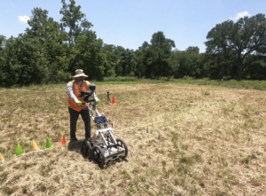
Magnetometry picks up buried metal and fire-affected soil (hearths, kilns, and similar features) by detecting contrast with the surrounding magnetic background. It’s the right call when the expected target actually behaves differently, magnetically, than the ground around it.
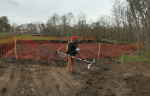
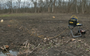
Electrical resistivity imaging (ERI) maps broader subsurface stratigraphy, distinguishing naturally layered soil from ground that’s been previously disturbed by human activity. It tends to earn its place when the area of interest is too large, or the depth of interest too great, for GPR or magnetometry alone.
Run the wrong method on the wrong ground, and the result isn’t just a weaker dataset. It can be a “clean” one that misses the target entirely, which is arguably worse than no survey at all. Choosing correctly, sometimes combining more than one method, is a geological decision made before the geophysical work even begins.
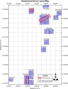
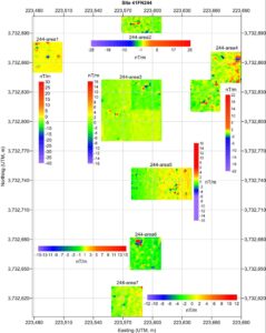
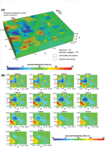
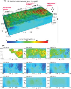
Here is an example in which both ground magnetic gradiometry (horizontal mode) and 3D ERI were used jointly to investigate two Caddo Period archaeological sites within the limits of a developing water reservoir in northeast Texas, USA.
Data doesn’t interpret itself.
Method selection is only the first place expertise shows up. The second is in reading what comes back.
A geophysical anomaly doesn’t arrive labeled. A contrast on a resistivity profile could be a buried wall, or it could be a natural change in soil moisture that has nothing to do with human activity. A void on a radar profile could be a significant feature, or a tree root, or a utility line nobody documented. Telling those apart requires geological context: knowing what naturally occurring subsurface conditions look like in that specific setting, so what’s actually anomalous stands out from what’s just normal variation in the ground.
Get this wrong in either direction, and it costs something. A false positive sends a project chasing a non-issue, burning time and budget on a false alarm. A false negative is worse. It clears a site that wasn’t actually clear, and the risk simply resurfaces later: mid-excavation, at the worst possible time, as the exact scenario a pre-construction survey was meant to prevent.
Due diligence, not a checkbox
A pre-construction cultural resource geophysical survey isn’t a way to avoid discovery, and it isn’t a compliance formality to satisfy a permitting office. It’s a way to control when and how discovery happens: on your schedule, as part of planning, rather than as an emergency mid-project.
That posture isn’t unique to archaeology. It’s the same due-diligence mindset that applies to geotechnical risk, karst hazards, or any other subsurface unknown a project might carry. Knowing what’s underground before you build isn’t a specialty concern. It’s just good planning.
If you’re evaluating a project with potential cultural resource exposure, or simply want to understand what a pre-construction subsurface assessment would look like for your site, we’re happy to talk through it.