In this guide, we’ll walk you through a simple 5-step process for using geophysical techniques like Ground-Penetrating Radar (GPR) and Electromagnetic Locators to pinpoint the exact location of utilities on your site.
Whether you’re a contractor, engineer, or project manager, mastering these methods can help you with locating utilities:
- Avoid costly utility strikes and delays.
- Streamline your design, planning process, and construction.
- Stay compliant with locating regulations
Understanding the role of utility locators in infrastructure projects
Utility strikes can severely affect infrastructure projects, causing service disruptions, safety hazards, and costly repairs. According to the Common Ground Alliance, utility strikes cost the U.S. economy approximately $30 billion annually. Accurate utility locating helps contractors and excavators avoid damaging existing infrastructure, minimizing project delays and cost overruns.
Utility locators use geophysical methods, such as ground penetrating radar (GPR), electromagnetic locating (EM), and acoustic locating, to identify and map underground utilities. By providing precise locations and depths of utilities, locators enable excavators to work safely around them, reducing the risk of accidents and service interruptions.

Unfortunately, accidents occur frequently due to poor excavation practices that ignore proper utility locations. In 2018, in accidents involving contractors hitting gas lines in Massachusetts, 522 times adequate precaution was not employed, and 413 times the lines were mismarked or not maintained.
Locating utilities facilitates design, planning, and construction
Utility locators provide critical information for the design of new infrastructure projects. By identifying existing utilities early in the planning process, designers can optimize layouts, avoid conflicts, and develop more efficient construction plans. This proactive approach saves time and money by reducing the need for costly redesigns and change orders later in the project.
Accurate utility data also enables design engineers to incorporate existing infrastructure into their plans, minimizing the need for utility relocations or modifications. By working closely with utility locators, design engineers can ensure that new infrastructure integrates seamlessly with existing networks, improving overall system performance and reliability.
Ensuring regulatory compliance
Many jurisdictions have legal requirements for utility locating before excavation. All 50 states have enacted “Call Before You Dig” laws in the United States, which mandate that excavators notify utility owners and request locates before breaking ground. Failing to identify and protect utilities adequately can result in fines, legal liabilities, and criminal charges.
Utility locators help project owners and contractors meet their regulatory obligations by providing thorough, accurate utility data. By documenting the locating process and maintaining detailed records, locators can demonstrate due diligence and protect project stakeholders from legal repercussions.
Understanding the One Call system
In the United States, the One Call system is a centralized point of contact for excavators to request utility locates. By dialing 811 or visiting their state’s One Call website, excavators can simultaneously submit requests to all affected utility owners. This streamlined process ensures that all necessary locates are performed before excavation begins, reducing the risk of utility strikes and legal complications.
Ready to eliminate the guesswork of utility detection? Now that we have reviewed the importance of identifying utilities, let’s explore how it’s done through geophysical explorations.
Step 1: Gather existing utility records and maps
Review existing utility maps and records
Before beginning any geophysical survey, it is essential to gather all available information about the site’s existing utilities. This includes utility maps, as-built drawings, and records from utility companies or local authorities. These documents can provide valuable insights into the location, depth, and type of utilities present in the area.
Requesting utility records
Contact the relevant utility companies and local authorities to request the most up-to-date records for the site. Be sure to provide them with accurate site information, including the address, property boundaries, and specific areas of interest. Some utilities may require a formal request process, so allow sufficient time for this step.
Analyzing utility maps and records
Once you have obtained the utility records, carefully review them to identify the location of known utilities. Pay attention to the utility type (e.g., water, gas, electric, telecommunications), the depth, and associated structures such as valves, meters, or junction boxes. Note any discrepancies or inconsistencies between different records.
Understand the limitations of existing records
While existing utility records can provide a starting point for your survey, it’s essential to recognize their limitations. Records may be incomplete, outdated, or inaccurate, particularly for older sites or areas with extensive development history.
Common issues with utility records
Some common issues with utility records include:
- Missing or incomplete information
- Inaccurate location or depth data
- Changes made to utilities after the records were created
- Unrecorded or abandoned utilities
According to the 2022 Damage Information Reporting Tool by the Common Ground Alliance, 37% of utility damage caused by excavating or drilling is due to bad locating practices, including unreliable utility records. This underscores the importance of field verification to ensure accurate and reliable data.
Prepare a base map for field survey planning
Using the information gathered from utility records, create a base map of the site to guide your field survey planning. This map should include:
- Property boundaries and key features (e.g., buildings, roads, landscaping)
- Known utility locations and depths
- Areas of particular interest or concern
Choosing an appropriate scale and format
Select a map scale that provides sufficient detail for your survey needs. A scale of 1:500 or 1:1000 is often appropriate for urban sites. Depending on your team’s preferences and the tools you’ll use in the field, decide on a suitable format for your base map, such as a digital CAD file or a hard copy print, depending on your team’s preferences and the tools you’ll use in the field.
Identifying potential survey challenges
As you create your base map, identify potential challenges or obstacles that may impact your geophysical survey. These could include:
- Areas with dense utility networks
- Regions with limited access or obstructions
- Sites with high levels of background noise (e.g., near power lines or transformers)
By anticipating these challenges early on, you can develop strategies to mitigate their impact and ensure a more efficient and effective survey.
Collaborating with stakeholders
Collaborating with stakeholders to gather additional site information and insights that may not be captured in formal utility records is crucial. This collaboration can help identify potential issues and ensure that all relevant information is considered during the survey planning process.
By incorporating these steps into your initial planning, you can ensure a more comprehensive and accurate survey that minimizes the risk of utility strikes and other issues.
Step 2: Conduct a visual site inspection
Walk the site to identify visible utility markers, manholes, and other surface features.
Before beginning the geophysical survey, conducting a thorough visual inspection of the site is essential. This step involves walking the entire area, paying close attention to any visible utility markers, manholes, valve covers, or other surface features that may indicate the presence of underground utilities.
When it comes to locating utilities, look for signs such as:
- Fire hydrants
- Junction boxes
- Telephone or electrical poles
- Utility flags or paint markings
- Meters or other utility-related equipment
As you walk the site, take detailed notes and photographs of relevant features. These visual cues can provide valuable information about the location and type of utilities present, helping to guide the subsequent geophysical survey.

Collaborate with site personnel.
During the visual inspection, it’s beneficial to collaborate with site personnel who are familiar with the area. They may have additional knowledge about the location of utilities or recent construction activities that could impact the survey. Engage in conversations with maintenance staff, facility managers, or other employees who can provide insights into the site’s utility infrastructure.
Note any potential obstructions or areas of concern for the geophysical survey
While conducting the visual inspection, be mindful of any potential obstructions or areas of concern that could affect the geophysical survey. These may include:
- Dense vegetation or trees
- Concrete or asphalt surfaces
- Buildings or other structures
- Large metal objects, such as fences, dumpsters, or vehicles
- Areas with high levels of background noise or interference
Make detailed notes about these potential obstructions, including their location, size, and other relevant characteristics. This information will be crucial when planning the geophysical survey, as it may influence the choice of methods or require special considerations during data collection.
As you assess potential obstructions, consider site accessibility and safety. Identify any areas that may be difficult to access due to physical barriers, such as locked gates or steep terrain. Note any safety hazards, including open excavations, unstable ground, or high-traffic areas.
Consult site personnel to discuss access requirements and safety protocols if necessary. Ensure all survey team members know of potential hazards and are equipped with appropriate personal protective equipment (PPE).
Update the base map with visual inspection findings
After completing the visual inspection, update the base map created in Step 1 with the findings from the site walk. This may involve:
- Adding symbols or annotations to indicate the location of visible utility markers, manholes, or other surface features
- Marking potential obstructions or areas of concern
- Highlighting any discrepancies between the existing utility records and the visual inspection findings
Incorporating the visual inspection data into the base map creates a more comprehensive and accurate representation of the site’s utility infrastructure. This updated map will be a valuable reference for locating utilities.
Step 3: Select appropriate geophysical methods
Selecting the appropriate geophysical method is crucial for accurately locating utilities. The two most common methods used in utility detection are Ground-Penetrating Radar (GPR) and Electromagnetic Locaters (EML). The choice between these methods depends on various factors, including site conditions, utility types, and the depth of the target utilities.
Ground Penetrating Radar (GPR)
GPR is a non-invasive geophysical method that uses high-frequency electromagnetic waves to create a subsurface profile. It is particularly effective for locating utility lines, such as plastic or metallic pipes, concrete sewers, rebar in concrete, and fiber optic cables, among other manmade features. GPR can penetrate depths of up to 30 feet, depending on soil conditions and antenna frequency.
GPR offers several advantages in utility detection:
- Detection of both conductive and non-conductive utilities.
- Provides depth information for accurate 3D utility mapping.
- Effective in complex environments with multiple utility layers.
However, GPR also has some limitations:
- Requires skilled operators for data processing and interpretation.
- Limited penetration depth in certain soil conditions (e.g., clay soils or soils with high water content).
- Potential for signal attenuation in highly conductive environments.

Electromagnetic Locators (EML)
EML, also known as cable locators or pipe locators, use electromagnetic fields to detect and trace metallic utilities, such as steel pipes, copper cables, and cast iron mains. They are susceptible and can detect utilities at depths up to several feet. However, they are less effective for non-metallic utilities.
EM locators offer several advantages in utility detection:
- Quick and efficient detection of conductive utilities.
- Ability to detect utilities at various depths.
- Portable and easy to operate.
However, they also have some limitations:
- Limited effectiveness for non-conductive utilities.
- Potential interference from nearby metallic objects.
- Difficulty detecting utilities in congested areas with multiple overlapping signals.
Selecting the right method
When choosing between GPR and EML, consider the following factors:
- Utility material: GPR is better suited for non-metallic utilities, while EML is more effective for metallic utilities.
- Depth of utilities: GPR can penetrate deeper than EML, making it a better choice for deeper utilities.
- Soil conditions: Soil moisture and clay content can affect GPR performance, while EML is less sensitive to these factors.
In some cases, combining both methods can provide the most accurate and comprehensive utility detection results.
By selecting the appropriate geophysical method(s) based on site conditions and utility characteristics, you can ensure accurate and efficient utility detection and set the stage for a successful geophysical survey.
Step 4: Perform the geophysical survey
Setting up the geophysical equipment and establishing a survey grid
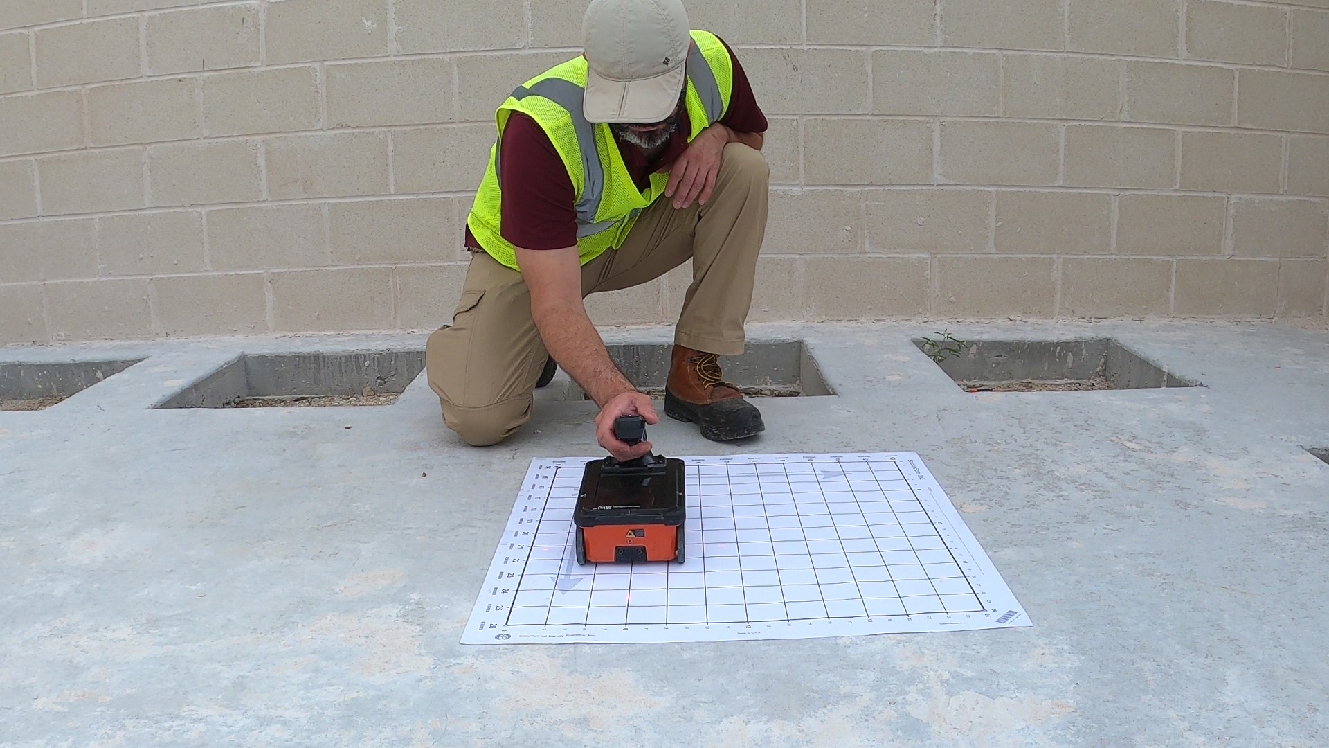
Before beginning the geophysical survey, it’s essential to properly set up the equipment and establish a survey grid. The specific equipment required will depend on the geophysical methods chosen in the previous step.

To establish the survey grid, determine the area to be surveyed and mark the boundaries with stakes or flags. Then, use a measuring tape or laser rangefinder to create a grid of survey lines, typically spaced 1 to 5 meters apart, depending on the desired resolution and the size of the target utilities. Ensure that the survey lines are perpendicular to the expected orientation of the utilities for optimal detection.

Calibrating the geophysical equipment
At Cordillera, we calibrate the geophysical equipment before collecting data to ensure accurate and reliable results. Some of the calibration steps we take are setting the appropriate time window and sampling interval for GPR, adjusting the gain and filter settings for electromagnetic induction (EMI) instruments, and checking the sensitivity and background noise levels for metal detectors.
Step 5: Interpret and map the results
Analyzing geophysical data to identify utility signatures
After conducting the geophysical survey, the next crucial step is to analyze the collected data. This process involves carefully examining the raw data obtained from the GPR or Electromagnetic Induction (EMI) methods.
The primary goal of this analysis is to identify the distinctive signatures and anomalies that indicate the presence of buried utilities. Each type of utility, such as water pipes, gas lines, electrical cables, and fiber optic conduits, exhibits unique characteristics in the geophysical data.
Recognizing utility signatures in GPR data
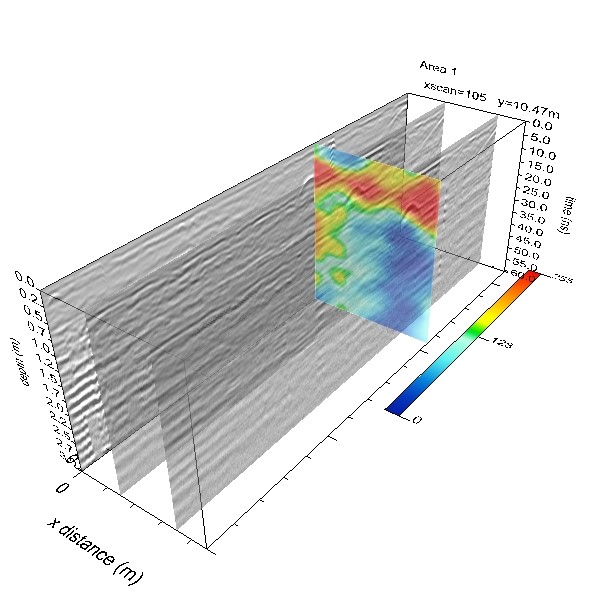
In GPR data, utilities typically appear as hyperbolic reflections or linear features. The shape and intensity of these reflections depend on factors such as the utility’s size, depth, and material composition. For example, metal pipes produce distinct hyperbolas, while non-metallic utilities may generate weaker or more diffuse signals.
Identifying utility anomalies in EMI and Magnetic data
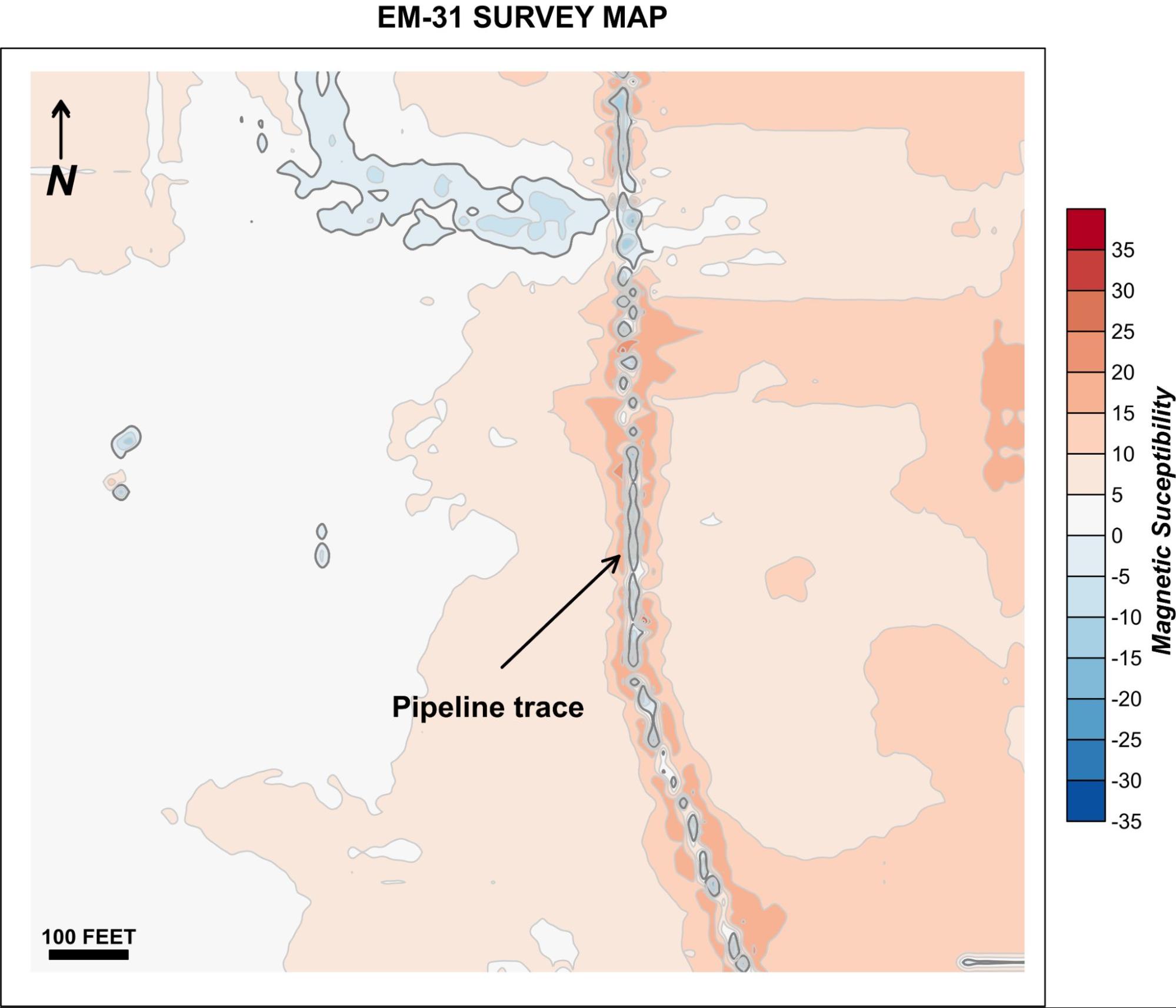
Electromagnetic Induction (EMI) and Magnetic data can help detect the presence of conductive or magnetic utilities. In EMI data, utilities manifest as linear features with elevated magnetic susceptibility values compared to the surrounding soil, like the example below. Similarly, in Magnetic data, ferrous utilities like steel pipes or cables appear as linear anomalies with higher or lower magnetic field intensity.

Correlating geophysical findings with existing records and observations
To enhance the accuracy and reliability of utility detection, it is essential to correlate the geophysical findings with existing records and visual observations. This process involves comparing the interpreted geophysical data with available utility maps, as-built drawings, and field notes. Locating utilities becomes more accurate thanks to this process.
Surveyors can validate the detected utilities and identify discrepancies or inconsistencies by cross-referencing the geophysical results with historical records. This correlation helps to minimize the risk of false positives or missed utilities.
Creating a comprehensive subsurface utility map
The final step in interpreting and mapping the results is to create a comprehensive Subsurface Utility Map that integrates all available information. This map visually represents the detected utilities, locations, depths, and characteristics.
Surveyors use specialized software tools to combine the interpreted geophysical data with existing records and field observations to create the Subsurface Utility Map. The software enables the creation of detailed, multi-layered maps that display the utilities in a clear and easily understandable format.
Incorporating utility attributes and metadata
In addition to the spatial information, the Subsurface Utility Map should include relevant attributes and metadata for each detected utility. This information may consist of the utility type, material, size, depth, ownership, and other pertinent details. These attributes enhance the map’s usefulness for future planning, design, and construction activities.
Collaboration with utility companies
Collaboration with utility companies is crucial for obtaining accurate and comprehensive utility data. Utility companies possess valuable information about their subsurface infrastructure, which can be leveraged to enhance the accuracy of GPR surveys. By working together, utility locators and companies can collect and document all necessary data, reducing the risk of utility strikes and legal complications.
Furthermore, private utility locators are vital in identifying and marking private utility lines, often needing to be documented in public records. These professionals specialize in locating and mapping private utilities, contributing to a more comprehensive understanding of the subsurface environment. Their expertise is crucial in projects where public utility records may need to provide a complete picture.
At Cordillera Geo-Services, we can help you with the following:
- Void detection
- Map bedrock depth
- Mapp buried foundations
- Leaking pipeline detection
- Locating Underground Storage Tanks (UST) and drums
- Beam locating
- Floor surveys
- Bridge deck surveys
- Concrete slab scanning and imaging
- Clearing of boring locations
- Measure concrete slab thickness
- Find rebar, post-tension cables, conduits, and non-metallic objects
For a complete list of applications, click here.

Locating utilities in practice
Now that you understand the importance of utility locating and the critical steps involved, it’s time to implement this knowledge. Start by assessing your current utility locating practices and identifying areas for improvement.
As you embark on your next project, prioritize utility locating as a critical component of your Subsurface Utility Engineering (SUE) strategy. By doing so, you’ll be well-equipped to manage risks, optimize designs, and deliver successful infrastructure projects.
