Environmental protection begins below the surface. Before contamination spreads, before a slope gives way, or before groundwater becomes polluted, there are early warning signs hidden underground. Geophysics allows us to detect and interpret those signs, offering a scientific basis for prevention.
By imaging subsurface structures, identifying anomalies, and mapping fluid or contaminant movement, geophysical surveys help engineers, developers, and environmental professionals make informed decisions that reduce ecological and financial risk.
At Cordillera Geo-Services (CGS), we integrate geological understanding with advanced geophysical methods to prevent problems before they occur or identify them before they worsen, providing clarity, confidence, and compliance at every stage of a project.
The Role of Geophysics in Environmental Protection
Environmental geophysics uses physical measurements of the shallow Earth to evaluate or help remediate problems in the Earth’s environment. It allows us to understand subsurface conditions without drilling or disturbing the site. It provides continuous, spatially rich data that complements borehole and laboratory analyses.
Common goals include:
- Detecting contamination plumes (leachate, hydrocarbons, produced waters, salts) before they reach sensitive receptors.
- Characterizing groundwater flow and potential pathways for pollutant migration.
- Monitoring remediation effectiveness through time-lapse geophysical measurements.
- Assessing stability and compaction in waste sites, embankments, and landfills.
- Locating buried infrastructure or tanks that could pose leakage risks.
These capabilities turn geophysics into a preventive science, enabling early intervention rather than costly cleanup.
Key Geophysical Methods for Environmental Stewardship
Each geophysical method targets a different physical property of the subsurface. The integration of multiple geophysical techniques yields a clearer and more reliable interpretation.
1. Electrical Resistivity Imaging (ERI)
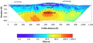
ERI measures how easily electrical current flows through the ground. Since fluids, salts, and contaminants often reduce electrical resistivity, this method is ideal for mapping leachate plumes, tracking infiltration, and delineating waste boundaries.
A case study from Indonesia demonstrated how 2D electrical resistivity profiles successfully delineated the extent of leachate spread in an open dumping landfill [1]. In similar U.S. contexts, ERI can identify subsurface contamination zones early, guiding remediation or landfill design.
2. Ground Penetrating Radar (GPR)
GPR transmits high-frequency electromagnetic waves into the ground and records reflections from interfaces between materials with contrasting dielectric properties. It’s especially effective for detecting buried infrastructure, shallow contamination, or voids.
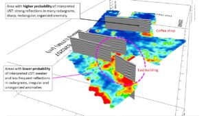
GPR has been applied successfully to locate underground storage tanks (USTs) and leaking pipelines that pose contamination risks [3].
3. Electromagnetic (EM) Induction and Electrical Conductivity Mapping
EM methods rapidly measure changes in soil electrical conductivity, revealing variations linked to contamination, salinity, or moisture content. When used across large areas, EM surveys provide fast, non-invasive screening for potential environmental concerns.
4. Seismic Methods
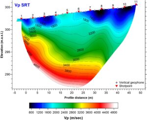
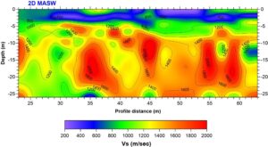
Seismic refraction tomography (SRT) and MASW (Multichannel Analysis of Surface Waves) help assess soil stiffness, compaction, and rippability. In environmental contexts, these data support landfill stability analyses, slope risk assessments, and site suitability evaluations.
5. Magnetometry and Borehole Geophysics
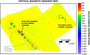
Magnetometry is widely used to locate buried metallic objects, such as drums, tanks, or pipelines. Borehole geophysical logging complements surface methods by providing high-resolution vertical profiles of electrical resistivity, natural gamma, and other parameters critical for contaminant characterization.
Integration: The Geological Context Matters
While technology drives data acquisition, interpretation grounded in geology transforms data into actionable insight.
At CGS, every environmental geophysical investigation is designed around site-specific geological frameworks and targets of interest— sediment types, structural features, hydrogeological conditions, and anthropogenic objects or influences.
This integrated perspective ensures that geophysical anomalies are correctly understood: distinguishing between natural lithologic changes and actual contamination or instability.
From Detection to Prevention
The preventive value of geophysics lies in its timing. By identifying anomalies before visible damage or contamination occurs, stakeholders can take action early, saving time, money, and environmental resources.
Examples of preventive applications include:
- Landfill assessment: ERI and EM mapping detect leachate migration before it contaminates groundwater [2].
- Brownfield redevelopment: Combined GPR and magnetometry locate buried waste or tanks to support safe excavation and compliance [3].
- Water resource protection: Seismic surveys (i.e., SRT, MASW) and ERI reveal fracture zones and flow paths that could connect contaminated and potable aquifers [4].
- Slope stability monitoring: Seismic refraction tomography and time-lapse ERI detect early signs of mass movement, enabling proactive engineering reinforcement [5].
In each case, the cost of geophysical assessment is minimal compared to the cost of environmental failure.
Case Studies
- Leachate Spread Detection Using ERI — A study in Indonesia applied 2D resistivity to map leachate plumes in an open landfill, confirming geophysics’ capability to delineate contamination zones [1].
- Multiscale Geophysical Characterization in Landfill Environments — ERI and EM imaging identified both leachate and gas migration patterns, demonstrating integrated environmental diagnostics [2].
- Detection of Underground Storage Tanks via Multiple Geophysical Methods — Showed the effectiveness of magnetometry and GPR in identifying buried metallic tanks [3].
- Hydrogeophysical Investigation for Groundwater Protection — Demonstrated the utility of resistivity and seismic methods in groundwater management [4].
- Time-lapse Geophysics for Slope Stability Monitoring — Highlighted the preventive role of seismic and ERI monitoring for landslide risk [5].
FAQ
Q1: How can geophysical surveys prevent environmental disasters?
By identifying contamination pathways, unstable ground, or hidden infrastructure before failure, geophysics enables early detection of contaminants in the subsurface, leading to remediation and design adjustments.
Q2: Which geophysical method is best for detecting contamination?
Electrical Resistivity Imaging (ERI) and Electromagnetics (EM) are typically most effective, though they are often combined with GPR for improved resolution.
Q3: Can geophysics replace drilling or sampling?
No — geophysics complements direct sampling by guiding where to drill, improving efficiency, and reducing uncertainty.
Q4: How often should environmental sites be monitored geophysically?
For high-risk or regulated sites, annual or biannual surveys can track changes in subsurface conditions and verify remediation success.
In conclusion
Environmental stewardship requires foresight, and foresight depends on information. Geophysics transforms the invisible into knowledge, helping engineers, developers, and environmental professionals make decisions that protect both projects and the planet.
At Cordillera Geo-Services, we call it seeing before digging. It’s not just smart science, it’s responsible engineering.
References
[1] Geophysical Survey on Open Dumping Landfill for Monitoring Spread of Leachate: A Case Study in Pekanbaru, Riau, Indonesia. Journal of Geoscience, Engineering, Environment, and Technology. journal.uir.ac.id
[2] Multiscale Geophysical Characterization of Leachate and Gas Plumes in a Tropical Landfill Using Electrical Resistivity Tomography. MDPI, Environments, 2024. mdpi.com
[3] Application of Multiple Geophysical Methods to the Investigation of Underground Storage Tanks. Earthdoc. earthdoc.org
[4] Hydrogeophysical Investigations for Groundwater Management. USGS Open File Report, 2022. usgs.gov
[5] Time-Lapse Electrical Resistivity Tomography for Landslide Monitoring. Engineering Geology, Elsevier, 2023. sciencedirect.com