Why did my new water well come up dry? Most dry water wells trace back to a few predictable mistakes: drilling on assumptions instead of data, missing the geological structure (aquifer) that holds water, mistaking poor-quality water for usable water, or stopping at the wrong depth (at the capillary zone or capillary fringe). All four can be evaluated before drilling with a geophysical survey, which maps the subsurface without disturbing it.
Free webinar:
How geophysical surveys help you find groundwater and minimize the risk of drilling dry holes.
Get access to the webinar →
Already have a project? Let’s talk.
Why does water supply put a project at risk?
For many developments, water availability is not a detail to settle later. A subdivision, an industrial facility, a municipal expansion, or a rural build may depend on a water well before anything else can move forward. When the first hole produces nothing, the cost is not only the drilling. The schedule, the budget, and every decision that assumed a water source all have to be revisited.
A dry hole is also not bad luck. It is usually the result of a premature decision made with too little information.
What does it mean when a well comes up dry?
A water well is considered dry when drilling reaches the target depth without finding enough water to be useful. A low-yield well is a related problem: it finds water, but not enough to meet demand. Both come from the same underlying issue, which is not knowing what is below the surface before committing to a drill location.
Why did my new water well come up dry?
Four causes come up again and again.
1. Drilling on geology or local knowledge instead of data
Surface geology and nearby water well logs are useful starting points. But groundwater does not always sit where they suggest. It concentrates in aquifers, but also in fractures, buried channels, and structural traps that are not visible from the surface, so a neighbor’s well can tell you very little about where water is on your site.
2. Missing the structure that holds the water
A fracture zone or a buried channel can be narrow. A well placed beside it, rather than on it, can come up dry even though water is close by. Locating these geological features requires mapping the ground’s physical properties, not guessing from the surface.
3. Mistaking the wrong target for the right one
Not every wet or conductive layer is a usable aquifer. Electrical resistivity, a physical property of Earth materials, is mainly affected by pore-fluid chemistry, mineral content, temperature, lithology, porosity, and water content, so a saline layer and a fresh-water layer can look different in an electrical resistivity survey. Surveys give clues about water quality before a drill rig arrives, though they don’t replace water-quality testing.
4. Stopping at the wrong depth
A well that stops short of the water-bearing zone comes up dry. Knowing the depth range before drilling lets the driller plan for it, instead of finding out after the fact. Therefore, understanding the aquifer parts before drilling is important. For instance, an aquifer consists of several key structural and hydrogeological parts that store, filter, and transmit groundwater: unsaturated zone, water table, capillary fringe, saturated zone (phreatic zone), permeable matrix (aquifer framework), recharge area, discharge area.
How do geophysical surveys help you avoid a dry well?
Geophysical methods measure physical properties of the ground, such as electrical resistivity, to map aquifers without drilling. For groundwater, the most common approaches are:
- Electrical resistivity imaging (ERI): maps resistivity variations related to water, rock, and soil, and is the most widely used method for groundwater detection.
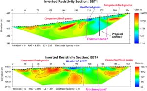
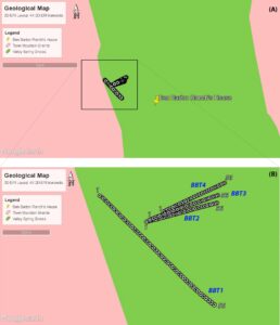
Above: the interpreted inverted electrical resistivity models of two transects. Areas with high resistivity values (shades of orange to red) are interpreted as competent/fresh gneiss zones. Weathered gneiss is interpreted as a low resistivity anomaly. The proposed drillhole for the water well is shown in BBT1. The map below shows the ERI profiles layout overlaid on the geological map.
- Electromagnetic (EM) methods: well suited to mapping conductive targets and practical for screening larger areas.

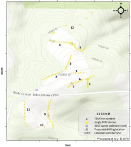
Above: the spatially constrained inversion of TEM profile number 4, depicted on the TEM survey layout overlaid on the topographic map. In the resistivity image, an upper resistive cap (>300 Ω·m) overlies a moderate-resistivity horizon (30–100 Ω·m) that persists at roughly 35–50 m depth beneath the surface across the full 98 m length, which is interpreted as the aquifer.
- Seismoelectric methods: sensitive to fluid-bearing zones, and a more specialized option when the stakes of a single well are high.
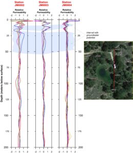
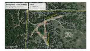
Above: a North-South cross-section through three adjacent seismo-electric sounding stations, also shown on the annotated aerial images. The larger aerial photo depicts the interpreted water-bearing fracture zones at several stations (red circles), located at the intersection of two fracture zones (yellow shades).
- Seismic methods: traditional seismic refraction or seismic refraction tomography of compressional seismic waves (P-waves) effectively locate the water table.
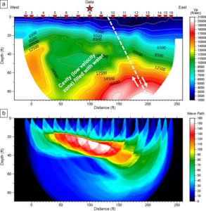
Inverted P-wave seismic refraction tomography (SRT) along a profile at Barton Springs in Austin, TX, USA. The SRT inversion indicates a water- and sediment-filled void anomaly (low-velocity zone) between 40 and 140 ft in a karstic terrain. The red triangles indicate seismic shot locations (2-16). Number 1 is an off-end shot. The SRT profile suggests a fault to the east of station 200 ft (source: Saribudak, 2026).
The right geophysical method depends on the target, the site’s geology, the depth you need to reach, and the size of the property. Combining methods generally improves your chances of success, because each one responds to a different physical property. Our guide to locating underground water explains each method in more detail.
What should a groundwater survey deliver?
A groundwater survey is only useful if a driller or an engineer can act on it. A decision-ready report should include:
- Recommended drilling coordinates
- Target depths
- Confidence rankings for each location
- A clear statement of what remains uncertain
That last item matters. A good report does not promise water or water yield. It ranks the options and tells you how sure it is about each one.
Can a geophysical survey guarantee water?
No, and a provider who says otherwise should raise questions. A geophysical survey reduces risk by showing where water is more likely and where it is less likely. It cannot remove geological uncertainty entirely. It replaces a single guess with ranked, data-supported options, so the decision to drill rests on evidence.
For a developer or planner, that is the practical value: fewer surprises and a defensible basis for your decision.
How do you know before you drill?
If your project depends on a new water well, first ask where the water is, how deep it is, and how confident you can be. Geophysics answers these questions before the first hole.

Above: active drilling at a location determined by an ERI survey.
WEBINAR: Know where the water is before you drill.
Dr. Héctor Hinojosa shows how resistivity, electromagnetic, seismic, and seismoelectric surveys locate groundwater, with real case studies (Texas).
Get access to the webinar →
Already have a project? Let’s talk.