Engineering Design Begins Below the Surface
Every engineering project—from bridges and roads to energy infrastructure, water management, and environmental remediation—relies on the stability and predictability of the ground beneath it. Subsurface uncertainty is one of the most persistent sources of design risk, schedule delays, and cost overruns.
Traditional boreholes, test pits, and soil samples offer valuable but limited point data. While these methods provide direct physical measurements, they cannot capture lateral variability or identify hidden targets or anomalies of interest between sampling points. As a result, engineers may design based on limited or incomplete information, leading to under- or over-engineered solutions, unexpected soil behavior, or unforeseen groundwater interactions.
Integrated geophysics and geology overcome these limitations by combining continuous, non-invasive measurements with interpretive expertise. This integrated approach produces a comprehensive subsurface model, allowing engineers to make informed decisions with confidence. Beyond cost savings, it strengthens safety, compliance, and sustainability.
The Cost of Incomplete Subsurface Understanding
Subsurface uncertainty is a major contributor to construction project overruns. Hidden voids, variable soils, perched water tables, or buried debris can necessitate redesign, additional materials, or rework, all of which inflate project costs.
Studies support this reality: a World Bank survey of 64 hydroelectric projects found that geological challenges led to major cost overruns in 36% of projects, with civil works costs increasing by an average of more than 65%. Tunneling projects, such as the Channel Tunnel and Olmos Tunnel, have reported overrun rates of 9–78% due to unexpected geological conditions.
By investing in integrated geophysical and geological surveys, engineers reduce these risks. Early detection of anomalies enables proactive design adaptation, precise foundation engineering, and the avoidance of hazardous areas. This predictive approach minimizes surprises, accelerates construction schedules, and reduces unnecessary expenditures.
The Complementary Roles of Geology and Geophysics
Geology: The Interpretive Framework
Geology provides the interpretive context that transforms raw subsurface data into engineering insight. By analyzing stratigraphy, lithology, structural features, and depositional history, geologists can anticipate how the ground is likely to behave under load, during excavation, or in response to changing water levels.
For example:
- Clay-rich soils may consolidate and settle over time, affecting foundation stability.
- Loose sands may be prone to liquefaction or subsidence if groundwater is removed.
- Fractured bedrock may transmit water or compromise load-bearing capacity.
Geology informs geophysical survey planning, method selection, and interpretation. Knowing the likely materials and structures present guides which geophysical methods are most effective, what frequencies or electrode arrays to use, and how to validate anomalies.
Geophysics: The Measurement System
Geophysical methods quantify subsurface physical contrasts, producing continuous datasets that reveal hidden conditions. Key methods include:
- Ground Penetrating Radar (GPR): Sends electromagnetic waves into the ground; reflections occur at interfaces with contrasting dielectric properties. High-frequency antennas (500–1000 MHz) resolve fine detail at shallow depths (proper for utilities, pavements, and archaeological remains), while low-frequency antennas (50–200 MHz) penetrate deeper to reveal geological layering.
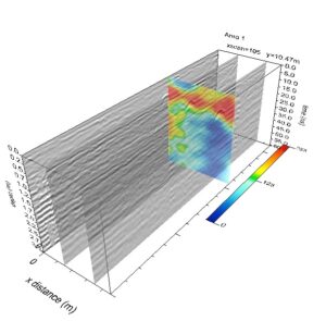
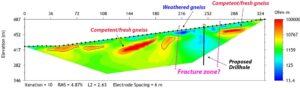
- Electrical Resistivity Imaging (ERI): Applies current through electrodes and measures voltage response to map apparent electrical resistivity variations, revealing features such as subsidence, fractures or faults, groundwater zones, buried fill, or contamination plumes.
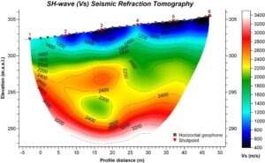
- Seismic Refraction Tomography & MASW (Multichannel Analysis of Surface Waves): Measures the seismic velocity of compressional and shear waves through soils and rock to determine their elastic properties, depth to bedrock, and weak zones.
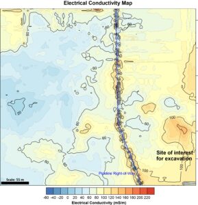
- Electromagnetic (EM) Surveys: Map conductivity over vast areas, ideal for landfill delineation, contaminant plume delineation, agriculture, and shallow groundwater studies.
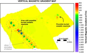
- Magnetometry: Detects magnetic anomalies, often associated with buried metal objects or archaeological features.
Each method has strengths and limitations. For example, ERI is excellent for measuring electrical resistivity anomalies suggestive of water-bearing materials, but less precise for resolving very thin layers; GPR provides high resolution but attenuates quickly in conductive materials such as clay-rich soils or saturated materials in general. Integrating multiple methods mitigates these limitations.
Integration: From Data to Decision
Individual geophysical surveys are powerful, but interpretation without geological context can mislead. For instance, a high-resistivity anomaly might indicate either a boulder, dry sand, or an air-filled void; geology clarifies the likely scenario and its significance.
Integrated analysis produces:
- 3D models of soil and rock layers
- Anomaly identification (i.e., utilities, voids, contamination, variable soils, depth to bedrock)
- Groundwater mapping
- Zones of potential hazard
These insights guide design choices: foundation type, excavation approach, dewatering strategy, slope stabilization, and material selection. They reduce uncertainty, prevent rework, and optimize project budgets.
Common engineering challenges revealed by subsurface investigation
| Engineering Concern | Typical Subsurface Cause | Diagnostic Method |
|---|---|---|
| Foundation instability | Weak layers, voids, variable fill | Seismic, ERI, GPR |
| Groundwater issues | Shallow aquifers, perched water tables | ERI, EM, hydrogeological logging |
| Slope or embankment failure | Fractures, weak planes, saturation | Seismic, ERI, and geological mapping |
| Utility conflicts or contamination | Buried infrastructure or waste | GPR, EM, magnetometry |
| Archaeological or heritage risks | Buried structures or remains | GPR, magnetometry, ERI, surface mapping |
Methods that deliver subsurface clarity
| Method | Strengths | Applications |
| Ground Penetrating Radar (GPR) | High-resolution shallow imaging | Utilities, pavements, archaeological sites |
| Electrical Resistivity Imaging (ERI) | Depth profiling, groundwater detection | Geotechnical, water resources, remediation |
| Seismic Refraction Tomography / MASW | Elastic properties, bedrock depth, and site classification | Foundations and other infrastructure types |
| Electromagnetics (EM) | Rapid shallow earth electrical conductivity mapping | Archaeology, agriculture, landfill delineation, and environmental surveys |
| Magnetometry | Detection of ferrous materials | Archaeology, industrial sites, UXO detection |
By combining methods and geological interpretation, engineers receive a continuous, accurate picture of subsurface conditions, enabling safer, more cost-effective design.
Engineering Benefits of Subsurface Clarity
- Improved Design Reliability: Precise geotechnical models ensure structures are safe and stable.
- Cost Efficiency: Fewer geotechnical boreholes, targeted excavation, reduced rework, and optimized materials.
- Enhanced Risk Management: Early identification of potential geological hazards protects workers, infrastructure, and the environment.
- Regulatory and ESG Compliance: Non-invasive surveys minimize disturbance and meet modern environmental and heritage standards.
Key Questions for Project Decision-Makers
How do geophysics and geology differ in engineering investigations?
Geophysics measures the physical properties of Earth’s materials and their contrasts, while geology provides a coherent interpretation of the geophysical data in a geological and geotechnical engineering context. Combined, they produce a reliable subsurface model.
Are geophysical surveys cost-effective?
Yes. They reduce unnecessary drilling, target or highlight high-risk areas, and minimize rework.
Can geophysics replace drilling?
No. Geophysical surveys complement geotechnical drilling, providing a continuous context of the subsurface conditions and guiding precise sampling.
What makes CGS different?
CGS integrates both disciplines (geophysics and geology) internally, ensuring accurate, actionable, and project-specific insight.
Conclusion: Building on Certainty
Subsurface clarity turns uncertainty into confidence. Integrated geophysics and geology enable engineers to characterize the site better, design safer, more efficient, and more responsible projects, minimize surprises, reduce costs, and maximize predictability.
Don’t build on uncertainty.
Book a consultation with Cordillera Geo-Services to explore how an integrated geological and geophysical investigation can strengthen your next engineering project.